
Hurricane Polo, an extremely powerful Category 4 storm, swirls off Mexico’s Pacific coast. See its path.

Hurricane Polo’s intensity oscillated between Category 4 and Category 5 on Thursday as its path started moving away from Mexico’s southwestern coast. The storm was expected to remain offshore, while its outer rainbands spread across southwestern Mexico, the U.S. National Hurricane Center said.
“Some near-term strengthening is possible, and Polo is expected to remain a powerful major hurricane for the next few days,” the Miami-based center said.
Elsewhere in the Pacific, Tropical Storm Nolo formed on Wednesday, triggering a hurricane watch for Hawaii’s Big Island. Nolo is expected to become a hurricane sometime Thursday.
Maps show Hurricane Polo’s path
As of early Thursday, Polo’s core was about 195 miles off the coast of Zihuatanejo, a coastal resort city in the Mexican state of Guerrero.
CBS News 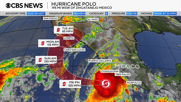
It was sending hurricane-force winds outward up to 40 miles from its center and tropical storm-force winds some 125 miles out. Polo was heading northwest at 9 mph.
Polo was forecast to bring tropical storm conditions to parts of the coastline on Thursday. In some areas, heavy rainfall “may produce life-threatening flooding and mudslides, especially in areas of steep terrain,” the hurricane center warned.
Although the storm has remained far south of Baja California, the center said Polo could still impact the peninsula this weekend, as forecast models suggested it would likely change directions Friday night and travel back toward land. But Polo will have weakened significantly by then.
The Mexican government issued a tropical storm warning for a stretch of the Mexican coast from Tecpan de Galeana, in Guerrero, to Manzanillo in Colima. A tropical storm watch was in effect from Punta San Telmo to Playa Perula, in the state of Jalisco. Tropical storm warnings are issued when forecasts indicate tropical storm conditions will develop in a particular area, while tropical storm watches are issued when those conditions are possible, but not imminent.
Parts of the states of Michoacán, Colima, Jalisco and Nayarit may still see 2 to 4 more inches of rain, with up to 6 additional inches possible in certain areas, the hurricane center said Thursday. Between 1 and 2 more inches of rain could also fall in coastal parts of Jalisco and Guerrero.
Along with rain, Polo was also expected to cause life-threatening surf conditions, including rip currents, along the southwestern Mexican coast and parts of Baja California. The surf conditions could also contribute to flooding.
Mexican leaders have ordered evacuations, opened shelters and deployed military troops to areas that could be affected by the storm.
Classes were suspended Thursday at schools across the city of Acapulco, along the coast of Guerrero, its municipal government announced. Shelters across the state remained open, and officials said they were coordinating with local and national authorities to prepare for additional impacts of the hurricane.
Michoacán authorities also canceled classes through Friday in municipalities along the coast, urging residents of those areas not to leave their homes unless it was essential.
Polo’s extreme rapid intensification
Polo underwent what’s called extreme rapid intensification, in which a storm’s wind speeds increase by 58 mph or more over the course of 24 hours, between Monday and Tuesday.
Its intensification was dramatic even by those standards, with winds that skyrocketed from 45 mph early Monday morning to 150 mph at around the same time the following day. The hurricane center described its transformation as “truly remarkable.”
Its maximum sustained winds climbed as high as 180 mph at one point, far exceeding the 157 mph threshold for Category 5, the strongest on the hurricane scale.
Polo’s central pressure — an indicator of its strength and potential destructiveness — made it the second-strongest hurricane on record in the Eastern Pacific, behind 2015’s Hurricane Patricia. The storm’s wind speeds tied 2009’s Hurricane Rick as the third-strongest on record for the region.
Unusually strong El Niño conditions this year have been amping up tropical cyclone activity in the Pacific, with warmer waters, moist air and less wind shear enabling storm formation.